 Live Music Archive
 Librivox Free Audio
 Metropolitan Museum
 Cleveland Museum of Art
 Internet Arcade
 Console Living Room
 Books to Borrow
 Open Library
 TV News
 Understanding 9/11
tv 9 News Now at 430am CBS October 29, 2012 4:30am-5:00am EDT
4:30 am

good morning. welcome back to wusa9's round the clock coverage of sandy. this is the rehoboth beach area. you can see the surf is definitely kicking up there and there's rain showers. we'll be hearing more from kristin fisher who is live in rehoboth. good more than and welcome to 9news now. today is monday, october 29. i'm andrea roane. mike hydeck, monika samtani all on board. howard bernstein, though, has today's forecast and it's all about hurricane sandy. we'll begin with a quick look though at closures. this is pretty easy. almost everything in the metro region is closed starting with the federal government.
4:31 am

most local governments also closed. emergency personnel, though, are still asked to report. every major public transportation agency is closed today, including metro transit and vre. pretty much every flight into and out of our region has been canceled. you're advised to call your airline first if you have any questions about getting in or out of town. marc is shut down today. amtrak canceled most of its northeast corridor trains. again it's pret much a quiet day. today is also the third day of an extended weekend for most school systems in our region, and we have all of this information on our website. it's wusa9.com. we keep it updated 24/7. very little traffic out there, but that doesn't mean we don't have problems and road closures. so let's go to monika samtani who's going to tell us about that. if you're planning to head around town, let me take you to a graphic. here at the bay bridge, level one wind restrictions. that means winds are 40 to 49
4:32 am
miles an hour. no empty box trailers are house trailers allowed across the bay bridge. they'll reassess that throughout the morning. right now it's level one. no delays through the area. if you're planning to use metro, the rail bus, metro access, all service is suspended. the best thing is to go to metro alerts for updates. that will be the case throughout the day today. if you're planning to use the bay bridge this morning, there are no delays. level one wind restriction. let's take a look around town. we'll go to our stat 50 camera. volumes are light. that's the way it's going to be throughout the metropolitan area this morning. it's not going to be the volume that is going to be the problem. as the winds come in, it's going to be the debris that i'm concerned about, the flooding i'm concerned about as well, and also power outages affecting major enter secretaries. you want to -- major intersections. you want to remember if the signal lights are out at a
4:33 am

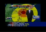
major intersection, treat it as a fourway stop. d.c. has already placed generators at major intersections so the lights will remain in place. but if they are not, treat it as a fourway stop. back to you guys. >> thank you, monika. we'll of course -- of course everything is hinging on what howard is looking at on his weather maps. has sandy's track changed? >> about the same as last night. when you went to sleep, we were talking about the worst being tonight into tomorrow morning. landfall in southern new jersey, northern part of the delmarva perhaps. very little has changed. we do have some rain. it's moving in. east is getting it first. this is a very unusual storm for a lot of reasons. one it's so big. two, it's hitting late in october. three, when we get hurricanes up here, they normally go north and parallel the coast. they don't slam into the mid- atlantic coast. of course there's heavy snow in the mountains. blizzards warnings up about 2500 feet from garrett county all the way down. winter storm warnings in the
4:34 am
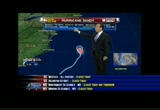
north carolina mountains. this is quite a storm. going to start you off with your day planner. as you can imagine we're looking at rain an wind and increasing rain and increasing wind. by this afternoon we could have gusts 40 to 50 miles an hour. i know things are pretty calm right now but just off shore of rehoboth about 15 miles, we've got winds gusting 58 miles an hour. the rain is going to pick up, too. it's already picked up just east of us. here's sandy with winds 75 miles an hour gusts to 90 from the national hurricane center. 2:00 a.m. advisory we'll watch the pressure. when the pressure stops, the storm is strengthening. winds around the center -- it's so big and so wide. it has a lot of central. would take a lot more to get it much faster. winds potentially 80 miles an hour making landfall south of atlantic city. don't fixate so much on where it makes landfall. we have tropical storm winds
4:35 am
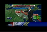
which extend 400-plus miles from the center. hurricane force winds extend about a hundred plus or so miles give or take from the center. that is tremendous. it's the right side of the storm to the jersey coast,up to new york. i think it's raritan bay, the south shore of long island, they've evacuated 375,000 people from the new york area for good reason. for us we're still going to be dealing with a storm with potentially 75 mile an hour winds tuesday morning near philly and up toward central pennsylvania. what does this mean for us? it means we could have gusts today to 50. tonight's gusts could be 60, 65, maybe 70 miles an hour. stronger gusts closer toward the center and lighter south and west but it's such a broad wind field that all of us will see very windy conditions. we're all under a high wind warning till tomorrow evening. that is snow that is falling in the higher elevations of west virginia. there could be more than a foot
4:36 am

of wind-driven snow. the eastern shore, they have all sorts of problems. we've got rain now especially east of d.c. it's picking up, southern maryland, the eastern shore. i just want to show you a couple more things before i get to the forecast. the wind field, these are the sustained wind forecasts from the hurricane center. these are 58 miles an hour and stronger. for the d.c. metro, especially east and northeast as we go throughout the nighttime hours, take will probably be the most destructive period with downed trees and power outages. 52 today. temps steadily falling. tonight 75 mile an hour wind gusts. tomorrow wind and rain. showers and wind in the afternoon. only 46. it's going to be cold tomorrow. wednesday blustery, 56 degrees with showers on halloween. thursday and friday a little bit better. could be a passing shower friday. then overthe weekend both 50 saturday, low 60 sunday and we turn the clocks back saturday night. andrea, back to you.
4:37 am
>> thank you. because it's one of the major counties our region which lies on the chesapeake, parts of prince george's county are expected to be greatly affected by the storm's high waves. joining us on the phone right now is ronald gill, jr. from the prince george's county's 311 center. thank you very much for being here this morning. what neighborhoods exactly are we talking about that -- >> i'm sorry, i didn't hear the last question. >> we were saying parts of the region lie on the chesapeake and that would include some parts of prince george's county. what neighborhoods are we talking about that might be affected? >> i don't have the specific neighborhoods that could be affected but we're looking at the impact that would affect the entire region of prince george's county. >> that's everybody. is anyone being ordered to evacuate from any particular regions in prince george's county that may be more
4:38 am
vulnerable than others? >> again, we don't have any one particular region. what we have done is we've opened one shelter located at charles flowers high school at 1001 -- [indiscernible] -- in silver spring, maryland. >> mr. gill, any other emergency preparedness that you're mobilizing for these vulnerable areas moving generators into areas that tend to lose power, water facilities, utility crews close by? what else are you doing? >> one of the biggest things we've done is we set up our emergency operations center. take allows us to bring our resources together to make the decision or any areas that are impacted, we will have the
4:39 am
utilities, both pepco, bge in our emergency operations center to take calls, fields calls and that way we can determine what areas -- what other major priorities that we need to address first in that order. >> mr. gill, we say you're with the county's 311 center. who should be calling that 311 number? >> we're using that and we want to urge our residents that if we have nonemergency calls, please contact 311. if you have trees down, if you're experiencing power outages, you want help in locating where the shelters are, that's the number we're urging our residents to call. >> mr. gill, after irene and after the derecho, do you feel that you're better prepared, you know exactly what needs to happen for this storm? >> i believe the county is very much prepared to deal with what
4:40 am

we are beginning -- [indiscernible] >> mr. gill, thank you very much. i do want to repeat ronald gill, jr. from the prince george's county 311 center says there is a shelter open. at 10:00 a.m. the richie coliseum will be open to shelter people on the campus of the university of maryland. again mr. gill, thank you and you be safe as well in this storm. 9news team coverage of hurricane sandy continues with a look at things on the northeastern shore. kristin fisher is live along rehoboth beach in delaware with a look at conditions there. chris continue, we saw shots of the surf and it was really starting to kick up. >> reporter: definitely starting to kick up. you know this is not your normal hurricane when you are dressed in full ski gear to cover it. it is cold and getting colder. windy and getting so much windier.
4:41 am

it is raining and it has been raining for well over 12 hours now. it's going to continue for at least 36 more hours. we are already seeing widespread flooding throughout rehoboth beach, dewey beach and down into ocean city. check out the surf behind me. i know it's dark but you can still sort of make out some of the waves as they come crashing into the shore. we're seeing about 14-foot high waves right about now. it's only going to get worse. high tide still about three hours away. you can see the got toe's pizza, -- grotto's pizza, one of the landmarks of rehoboth beach. it's boarded up as are all the businesses along the boardwalk. they are under a mandatory evacuation order starting yesterday at 6:00'. all businesses required by state law to be closed. most folks have either gotten out of town or they're hunkering down, although a lot of folks here are still sticking around. i'm little bit surprised by that because yesterday i was talking to the governor of delaware.
4:42 am

and he was saying that yesterday -- keep in mind this was around 4:00 yesterday in the afternoon. he was telling me that at that point in time, it was just as bad as hurricane irene and we were still so many hours away from getting the heart of hurricane sandy. so it is still 350 miles away from us, the center of it at least. lots of road closures here. the bayside in particular already seeing some significant flooding. there is going to be a mandatory travel ban essentially in effect for this area of rehoboth beach starting at 5:00 a.m. this morning. local law enforcement says they are not going to be taking any chances. they are going to be turning around everyone. nobody is going to be allowed to be driving on the streets except for law enforcement personnel. and hopefully us the media. a little bit later on we'll be heading out into this stuff. hopefully this will be the driest you're going to see me for the next few hours. for all you folks at home, i know we've been saying this
4:43 am

throughout the morning, but if you lose power, you can't see us on your tvs, you can watch us online or on your iphone or ipad. it's what we're doing out here since we can't get the signal back in town. hopefully things aren't going to get too much worse but this is still very, very early into this storm. 36 hours to go. back to you. >> a long 36 hours. kristin fisher, thank you. of course be safe out there. we have you covered. you heard kristin say it. you can follow us on tv, on your ipad, iphone. we'll be right back.


4:46 am
increasing wind and rain. temperatures will be falling off slowly. 51 at noon. 49 by 6:00 p.m. winds 40 gusting to 50 or more by 6:00. you can see the moisture. very heavy rains along the coast. we've got rain and snow in west virginia. they have blizzard warnings from garrett county southwest to higher elevations about 2500 feet in west virginia. around here we're just waiting for sandy's wrath to really move on shore. maybe a few more showers you can get some prep done before you have to start hunkering down. they're hunkering down in old town alexandria where my colleague jessica doyle is. probably tonight will be the most concern with coastal flood warnings. expecting tides 1 to 3 feet above normal. >> reporter: that's exactly right, howard. i'll bring you live on the scene here in old town alexandria. historically an area that floods first when we talk about flooding in the washington area. old town and the huntington
4:47 am

section of alexandria both tend to be flood prone areas. let me show you the scene live on the potomac river. you can see some lights on the other side. the water is starting to rise. low tide came in at about 3:02 this morning. high tide this morning is coming in at 8:45. i can tell you right on the scene here, we've already seen in the last hour that we've been in position that the water has risen about half a foot already. expectations at this point are on a normal day between low and high tide, you get a 3-foot rise in the water. it's going to be about 12 to 24 hours before that runoff starts hitting the potomac. let me tell you, this could be a very bad situation. driving here we saw sandbagging only at about 10% of the businesses that we saw driving over to this particular spot. so people are hunkered down but it doesn't look like there is a lot of fear in the area. i think people have been through this many times before. they know the drill but this is
4:48 am

a storm like no other that we've seen in a very long time. keep it with us here on wusa9 and wusa9.com online. we will be right back.
4:49 am

good monday morning. no surprise you're under a severe weather alert with hurricane sandy bearing down on the region. temperatures will slowly be
4:50 am
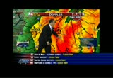
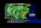
falling. 51 by noon. sustained winds. we could be gusting 50, maybe 60 east of us by 5:00 p.m. and the rains are going to be torrential at times. by the time the storm is over, we could be looking at 5 to 6 inches of rain here in the metro. maybe 58 to 10 south and east of us where we've been seeing the heavy bands. they were pouring yesterday across the bay. we'll zoom in on doppler 9000. you'll see all the deeper oranges we're seeing. there's a lot of heavy rainfall out there already coming from delaware to the eastern shore. now getting closer and closer to the metro with moderate rains. even across the metro. eastern fairfax county east see be the steadier, heavier rains, lighter rains as you go west of washington. but all of this is moving toward the west as the storm is moving toward us. i want to show you sandy's wind field, a hurricane right now. winds of 75 miles an hour
4:51 am
gusting to 90. it looks like the winds are maybe going to get a little bit stronger here before it makes landfall. expecting a landfall, at least a hurricane at 8:00. the center might not cross the coast till 1:00, 2:00 a.m. around here, though, look, tropical storm force winds. these are sustained winds as forecast from the national hurricane center getting out into western maryland and the mountains, most of virginia with the more damaging 58 mile an hour-plus winds getting in toward our eastern suburbs, northeastern, southeastern suburbs, northern neck, southern maryland, the eastern shore. they're probably going to see the worst of the winds as we go overnight. overnight tonight about 8:00 p.m. to 8:00 a.m. tomorrow, i think that will be the worst of the winds around here. still quite windy right through tuesday evening where the winds could still be gusting 40 to 50 miles an hour. then winding down some tuesday night into wednesday. it's chilly, especially in the mountains. garrett county 36 now. you guys have a blizzard warning. we're in the upper 40s. 54 in town with 55 annapolis.
4:52 am

outside on our michael & son camera, just some light rain. still good visibility. winds north at 17 at the moment. but they are going to pick up of the rainfall is going to pick up, too. this is one computer's forecast projection of the rain over the next three days or so. you'll notice we're not looking at the -- you'll notice we're now looking at the 5 to 8 category. in the mountains could be in the form of snow. you still have some time to pack your freezer, even if you've got some jugs and you put water in them and freeze them. increase the freezer mass. get your lawn furniture inside. clear the drains. sleep downstairs if you have trees near your house. the worst tonight at 8:00 to tomorrow 8:00 a.m. tomorrow we're dipping down into the 40s. staying in the mid-40s tomorrow. heavy rain in the morning. showers in the afternoon. could be a shower on wednesday
4:53 am
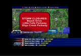
56 degrees. by thursday and friday better. maybe a shower friday. let's check in with monika and see if we have any traffic concerns. a lot of stuff is closed already. a lot of stuff is closed already. i'm going to breeze through the essentials right now. first of all metrorail bus, metro access radio, all services sus -- -- all services suspended. beach drive between the d.c.- maryland line and grovener lane in anticipation of flooding. sligo creek parkway as well wayne avenue to piney branch road. the airports remain open but most flights are canceled. you want to check ahead with your airline on that of the canceled again metro, marc, acela, vre, fairfax connector, amtrak as well. wasn't to call 1-800-usa-rail for updates. no house trailers or empty box trailers allowed right now on
4:54 am

the bay bridge. we'll get an update from calvert beach. >> reporter: good morning, monika. we didn't see any problems getting into chesapeake beach. we seen saw a couple of gas stations open overnight. as you can see behind us action these boats are parked for storm sandy. if you come down with me here, this sidewalk is already starting to see water pool up here. the water level is already rising here. we're going to show you some video from the weekend that our crew shot. we saw people getting ready for the storm, pieing down the boats. we actually saw some people putting boorpds up on their businesses and houses and putting sandbags up preparing to get hunkered for the storm. this town like all of maryland is under a state of emergency which means that they're prepared. they gave three sandbags out all weekend. and we'll be here all morning
4:55 am

giving you updates. right now we're not seeing any wind. we're seeing this steady rain. not that much wind like kristin was saying. more of the steady rain over the chesapeake bay could see 2 to 8 inks. stay with us on -- inches. stay with us on 9news this morning. we'll be right back.

4:57 am

welcome back. 4:57. a light rain in town. heavier rain east. rain and wind will be picking up especially this afternoon. 51 by noon, northwest winds 29 gusting by then could be 35 to 40. 50 at 3:00. some of the gusts later this afternoon toward evening could start to get toward the 50, maybe 60 mile an hour range as sandy heads our way. over to you. >> thank you, howard. as we mentioned, all d.c. government buildings and
4:58 am

facilities are closed today. starting at 10:00 this morning, five d.c. public recreation centers will operate as emergency shelters and recovery sites. they include guy mason recreation center in northwest. emery recreation center. turkey thicket recreation center at 1100 michigan avenue northeast. deanwood recreation center at 1350 49th street also in northeast and bald eagle recreation center at 100 joliet street southwest. residents are asked to please call 311 to report downed trees. only call 911 for true emergencies. and all d.c. residents are being asked to stay home and stay indoors. montgomery county has three shelters which will open at noon today. they're at the white oak community recreation center. that's at 1700 april lane in silver spring. and this one is for people and their pets.
4:59 am

it is the only shelter, itself one in white oak -- the one in white oak that will be accepting pets. the other two for people only. they're the activity center at bohrer park at 506 frederick avenue, gaithersburg and the mid country recreation center, 2004 queensguard road in silver spring. good morning. thank you for watching 9news now at 5:00 a.m. as we track hurricane sandy. i'm andrea roane. she is a big storm. sandy shut down metro trains, buses, pretty much all transportation is at a halt. >> and your voice. >> i apologize, ladies and gentlemen. i'm doing my best with saltwater and everything else. >> let's take a rundown of what is closed. that's almost everything in our area. metro trains and buses as well as most public transit here and up and down the east coast closed. the federal government is closed as are most local governments. the same
258 Views
IN COLLECTIONS
WUSA (CBS) Television Archive
  Television Archive News Search Service
Uploaded by TV Archive on
